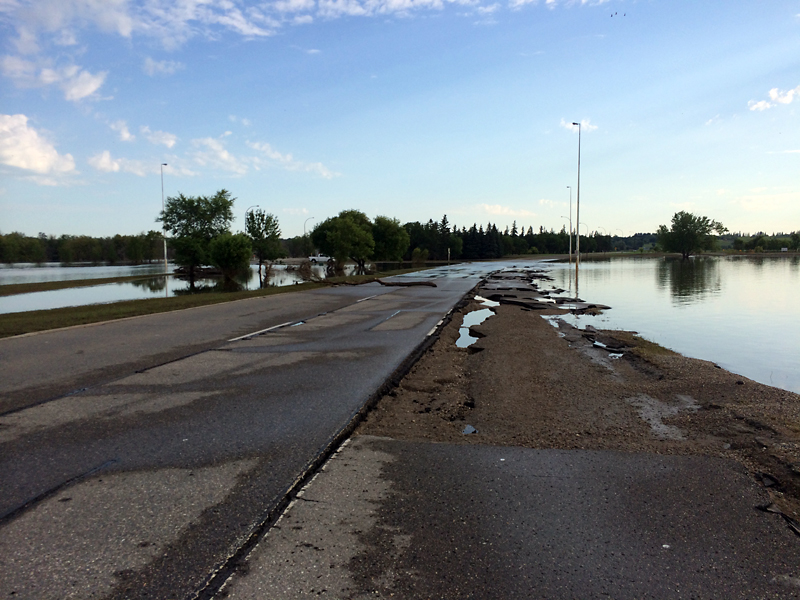
First St. awash in damage
Advertisement
Read this article for free:
or
Already have an account? Log in here »
We need your support!
Local journalism needs your support!
As we navigate through unprecedented times, our journalists are working harder than ever to bring you the latest local updates to keep you safe and informed.
Now, more than ever, we need your support.
Starting at $15.99 plus taxes every four weeks you can access your Brandon Sun online and full access to all content as it appears on our website.
Subscribe Nowor call circulation directly at (204) 727-0527.
Your pledge helps to ensure we provide the news that matters most to your community!
To continue reading, please subscribe:
Add Brandon Sun access to your Free Press subscription for only an additional
$1 for the first 4 weeks*
*Your next subscription payment will increase by $1.00 and you will be charged $20.00 plus GST for four weeks. After four weeks, your payment will increase to $24.00 plus GST every four weeks.
Read unlimited articles for free today:
or
Already have an account? Log in here »
Hey there, time traveller!
This article was published 22/07/2014 (4224 days ago), so information in it may no longer be current.
As the water goes down, the damage to First Street North is slowly being revealed.
The rapid flowing water lifted large portions of pavement from the northbound lanes, but other sections are still under water.
“It is looking like one lane is in much worse condition than the other,” said Herb Mahood, regional director with Manitoba Infrastructure and Transportation. “We will likely open traffic with one lane each direction while finishing repairs as soon as the water is gone and it is deemed safe.”

Manitoba Infrastructure and Transportation estimates that it will still be a couple of weeks until the water has gone down enough to do a proper inspection and begin repairs.
Water still covers much of the southbound lanes.
“It is too early to tell the cost of repairs,” Mahood said. “But relative to the overall damage in the southwest corner (of the province), this is small.”
He also stressed the importance of a full assessment of the First Street bridge. This year’s peak, which exceeded the former 2011 record, could have damaged the structure.
The City of Brandon says that the river level was measured Monday morning at 1,178.7 feet above sea level. That’s down three inches from the morning before, but is the same level that was measured Sunday night.
The reading at 1 p.m. Monday showed the river dropping to 1,178.5 feet above sea level.
All told, the river has dropped four feet, eight inches since its second, record peak on July 13.
The city closed First Street North on the morning of July 4, following a plan devised after the flood of 2011 that saw officials concentrate on protecting 18th Street North and Highway 110.
When the road was closed, the river level was measured at about 1,178.5 feet above sea level, the same measurement seen at 1 p.m. Monday.
» mlane@brandonsun.com
» Twitter: @megan_lane2
